


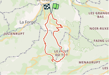
BOUVACÔTE À MOYEMONT

Regisconraud
User

Length
13.6 km

Max alt
854 m

Uphill gradient
444 m
Km-Effort
19.5 km

Min alt
628 m

Downhill gradient
443 m
Boucle
Yes
Creation date :
2020-05-22 12:12:17.729
Updated on :
2020-05-22 16:06:58.963
3h53
Difficulty : Easy

FREE GPS app for hiking
 SityTrail
IGN / Geographical institutes
SityTrail Plus
The world is yours!
About
Trail Walking of 13.6 km to be discovered at Grand Est, Vosges, Le Tholy. This trail is proposed by Regisconraud.
Positioning
Country:
France
Region :
Grand Est
Department/Province :
Vosges
Municipality :
Le Tholy
Location:
Unknown
Start:(Dec)
Start:(UTM)
332595 ; 5326887 (32U) N.
Comments
👍👍👍